
Ethnographic Story Maps Provide Insight into Oklahoma Watersheds
 Dr. Jack Friedman, a research scientist at the University of Oklahoma’s Center for Applied Social Research (OU CASR), has led a team of scholars in conducting multi-year ethnographic research in four Oklahoma watersheds as part of the Oklahoma NSF EPSCoR project that addresses “adapting socio-ecological systems to increased climate variability.” Dr. Friedman, together with postdoctoral fellows Drs. Mike Stanton (Sterling College, VT) and Tony VanWinkle (OU), recently released ethnographic story maps of Kiamichi, Cimarron, Washita, and North Canadian watersheds via the Oklahoma NSF EPSCoR website.
“Our story maps are a combination of narrative text, images, multimedia content, maps, as well geographies, to convey the social and environmental histories of the watersheds,” Friedman said. “We are putting these story maps together in a simple and user-friendly format to provide public outreach and education.”
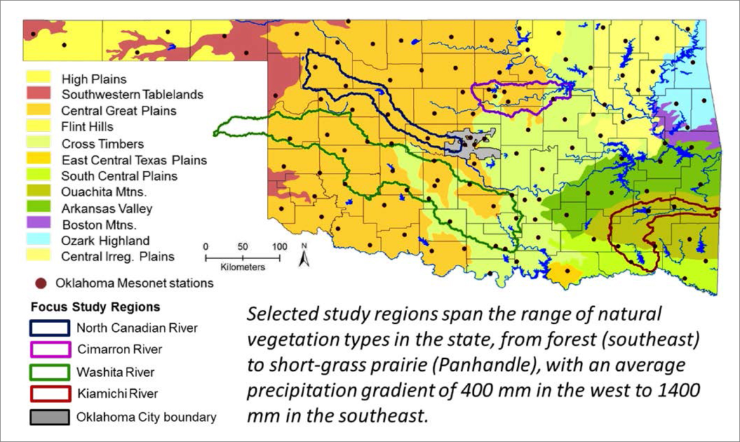
The first story map focuses on the Kiamichi Watershed located in southeastern Oklahoma. The watershed lies primarily within the Ouachita Mountains ecoregion, which has a higher average rainfall compared to western Oklahoma. The watershed encompasses two major lakes (Sardis Lake and Hugo Lake) that are the object of separate, complex water disputes.
“The Kiamichi Watershed lies within the Choctaw Nation, [and it has faced] a rich and often controversial history of land and resource use,” notes Dr. Stanton.
The second story map centers on the Cimarron Watershed, which links West Central and North Central Oklahoma. This watershed includes Lake Carl Blackwell, Lake McMurtry, and Keystone Lake. In this watershed, drought. and red cedar encroachment drive extreme fire risk. Water demand has grown significantly in the past 20 years, and surface water supply has been severely depleted during recent droughts.
“Our story map focuses on the Lower Cimarron Watershed, which contains a complex mosaic of rural, semi-rural, suburban, agricultural, and industrial landscapes from the northern part of Oklahoma City through Stillwater and northwest Tulsa,” Dr. VanWinkle said.
Another story map focuses the Upper Washita Watershed, which lies in southwestern Oklahoma. The story map centers on Fort Cobb in Caddo County, which is located north of the Washita River.
“Caddo County is not only one of the most agriculturally productive regions of the state, it also displays a wide array of natural resources and possesses a colorful and complicated cultural history as home to seven federally recognized tribes,” notes Dr. VanWinkle.
The final story map highlights the North Canadian Watershed, a watershed that feeds the primary water supply reservoirs for Oklahoma City and spans a rural region that is projected to experience increasing water shortages in the coming decades. Focused on a number of counties surrounding the city of Woodward, Oklahoma, this story map describes the complex relationship between changing land-use and the natural resources of the region. This story map captures the shift from the prehistoric Native American; to the growth of the region associated with the expansion of railroads into the West and the critical role the region played in the movement of cattle along the Great Western Trail; to the struggles to eke out a living as a farmer in a land plagued by drought, tornadoes, and severe ice storms; to the transition, beginning in the 1950s, toward an increasing reliance on the energy industry, including, most recently, an increasing commitment to wind power.
As Dr. Stanton notes, “The complexity of socio-economic and ecological issues [in the North Canadian Watershed] is the result of ongoing boom and bust cycles. The North Canadian Watershed provides unique insights into ways of adapting to shifting cycles of economic and climate conductions.”
In order to create the story maps, Friedman’s team conducted participant observations and recorded one-on-one interviews with a range of participants including farmers, ranchers, municipal water managers, natural resource manager, local business owners, local educators, landowners, members of prescribed burn associations, members of conservation groups, and local Native Americans. At some sites, the team conducted surveys of land use and the interaction with the natural environments. The team also gathered information through archival research and both publically available and new, never-archived databases.
Each story map links the landscapes of each watershed together with their local cultural and industrial history, economics, politics, hydrology, and ecology, in order to understand the resource use and allocation; how these aspects come together to shape some of the current conflicts in and around the watershed; and how these factors may affect or may be affected by variable climate conditions and future climate scenarios. These story maps will be useful tools for efficient management of watershed resources and conflict resolutions. In addition, as this research is ongoing, the story maps will also be living documents, being update to reflect emergent findings.
Learn more from the respective watershed’s history, resource use, and the ethnography that bring the stories to life by clicking this link http://www.okepscor.org/ethnographic-story-maps.
Funding for this project was provided by the National Science Foundation under Grant No. OIA-1301789 through the OK NSF EPSCoR.
------------
Story written by Pamela Abit, EPSCoR program coordinator. For more information about this research project, contact Dr. Jack Friedman at [email protected].