Mapping and Monitoring of Eastern Redcedar Forests in Oklahoma from Space

Eastern redcedar (Juniperus virginiana) is an evergreen tree species that is widely distributed in the Great Plains, especially Oklahoma, Texas, and Kansas. Eastern redcedar encroachment into grasslands is a major issue in Oklahoma, as it can cause changes in biodiversity and wildlife living in the habitat, reduce land for forage and livestock production, increase wildfire risk, and also reduce stream flow, groundwater recharge, and water supply.
Dr. Xiangming Xiao from the University of Oklahoma’s Department of Microbiology and Plant Biology led a research team of graduate students (Jie Wang, Russell B. Doughty), post-doctoral researchers (Yuanwei Qin, Jinwei Dong, Geli Zhang), and undergraduate students (Nicholas Cejda, Brian Alikhani) in collaboration with Oklahoma Forestry Service (George Geissler) to map the historical encroachment of eastern redcedar into grasslands over 10 counties across central and western Oklahoma during 1984-2010.
“Without the ability to understand these patterns and dynamics at which eastern redcedar is encroaching our grasslands historically, researchers would not be able to accurately predict the extent to which increasing climate variability could cause further redcedar encroachment into Oklahoma grasslands,” Xiao added.
Climate change and climate variability have been recognized to be one of the driving factors of eastern redcedar encroachment. Other factors include fire and livestock grazing management.
“Until our efforts, there were no maps to illustrate the spatial patterns and dynamics of eastern redcedar forests over several decades at 30-m spatial resolution and annual temporal resolution,” Wang said.
To generate time series maps for monitoring and tracking eastern redcedar encroachment in Oklahoma grasslands, the research team developed a novel and robust algorithm that combined Landsat images from 1984-2010 and Phased Array type L-band Synthetic Aperture Radar (PALSAR) data from 2010 with the Google Earth Engine (GEE) cloud computing platform.
“We are the first group, to our knowledge, to develop a pixel- and phenology-based approach to combine different types of remotely sensed imagery to generate a time series map of eastern redcedar encroachment in Oklahoma,” Wang said.
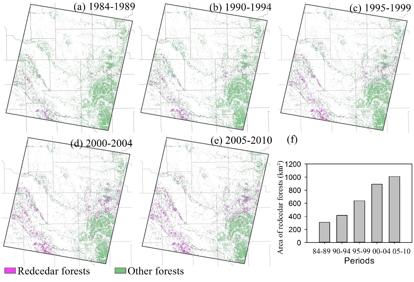
Eastern redcedar forest maps during the five historical time periods (see figure) show an increase in area encroached with eastern redcedar trees. This also shows that time series Landsat images and PALSAR data can be used to track redcedar encroachment over time.
“We found a significant redcedar encroachment in Oklahoma grasslands,” Wang said. “Eastern redcedar forests, which is the late stage of woody plant encroachment, increased at approximately 8% per year during 1984-2010 in those 10 counties.”
“In late 1980s eastern redcedar forests were mainly distributed in the Caddo, Blaine, Dewey, Logan, and Payne counties, these counties also had the largest increase in eastern redcedar forests in 1990s and 2000s,” Wang added.
“Apart from the funding we received from OK NSF EPSCoR, we have forged our partnership with the Oklahoma Department of Agriculture, Food and Forestry in developing these maps,” Xiao said.
These time series maps of eastern redcedar forest are vital for rangeland management, conservation planning, biodiversity assessment, hydrological and climate change studies.
A follow-up work has also been published in Remote Sensing of Environment journal by Dr. Xiao's group, which reports annual maps of the historical encroachment of eastern redcedar and ashe juniper into grasslands over the entire Oklahoma during 1984-2010. More information can be found using this link https://www.sciencedirect.com/science/article/pii/S0034425717305680.
Funding for this project was provided by National Science Foundation under Grant No. OIA-1301789 through OK NSF EPSCoR and an award from USDA-NIFA.
Pictured above: Eastern redcedar forest maps in five time periods (1984-2010).
Download a print version of the story
___________
Story Written by Dr. Pamela Abit, Oklahoma NSF EPSCoR Program Coordinator. For more information about the redcedar research highlighted in this article, contact Dr. Xiangming Xiao at [email protected].
