Measuring Open Surface Water Body Area in Oklahoma from Space

Oklahoma has the largest number of man-made lakes and reservoirs in the U.S. Despite the importance of these open surface water bodies for public water supply, agriculture, thermoelectric power, tourism, and recreation, it is unclear how these water bodies have responded to climate variability and change as well as anthropogenic water use in the past decades. Precipitation and temperature are two main climatic factors affecting changes of open-surface water body area. Reduced water body area due to severe drought may impact ecosystem services, cause changes in biodiversity of a particular habitat, and reduce water supply, which led to massive groundwater mining especially in the Southern Great Plains. Prolonged drought in 2011 caused extensive crop failures across the Southern Great Plains. Likewise, decreased streamflow due to drought in Kiamichi River in Southeastern Oklahoma led to decreases in freshwater mussels by more than 60% during 1992-2011.
“Due to climate variability and change, changes in water body area and number in Oklahoma would affect our society and ecosystems. However, it is still unclear how open surface water bodies, which are mostly man-made, have and will respond to climate change because we have limited data, information, and knowledge on this matter in Oklahoma,” Xiao said.
Hence, Dr. Xiangming Xiao from the University of Oklahoma’s Department of Microbiology and Plant Biology led a team of graduate students, post-doctoral researchers and research scientists (Zhenhua Zou, Jinwei Dong, Yuanwei Qin, Geli Zhang, Jie Wang, Russell Doughty, and Michael Menarguez) to conduct a study on measuring open surface water body across the state using remote sensing.
Dr. Xiao’s team used all available Landsat 5, 7, and 8 images from 1984 through 2016 archived in Google Earth Engine (GEE) cloud computer platform, and spectral index- and pixel-based mapping algorithms to identify and map open surface water body areas at 30-m spatial resolution, and analyzed the spatial-temporal variability of these water bodies and its relationship with climate and water use.
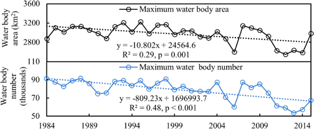
The team published their first paper at the Science of the Total Environment journal in 2017 and reported significant downward trends in the maximum, year-long, and annual averaged surface water body areas from 1984-2015 in Oklahoma. These decreases were mainly attributed to the continued shrinking of large water bodies wherein the annual water body area shrank 10 km squared each year over the last 3 decades across the state.
“There were also significant decreases in maximum year-long water body numbers, which suggested that some of the water bodies, especially small ones, may be vanishing year by year,” said Zhenhua Zou, lead author and graduate student on the team.
Dr. Xiao and his team applied the same methods to study open surface water body areas in the contiguous United States. In March 2018, they published their second paper at the Proceedings of National Academy of Sciences of the United States of America and reported that Oklahoma is one of the 10 states across the nation that had significant decreasing trends in year-long water body areas in the last 32 years.
In Oklahoma, both water body area and number were positively related to precipitation, but negatively related to temperature. This means that more precipitation results in more water bodies and larger water body area while higher temperatures will increase evaporation and agricultural demands that may eventually reduce water body area and number,” Zou added.
“Surface water withdrawals influenced the year-long water bodies. The smaller water bodies have greater risk of drying under drier climate, which suggests that small water bodies are more vulnerable under climate-warming scenarios,” Xiao said.
Findings of this research can be used to assist decision makers and stakeholders in developing and implementing water-resource planning and management as well as agricultural irrigation and ecological conservation strategies in coping with increasing water stress, unprecedented droughts, and uncertain impacts of increasing climate variability.
Funding for this project was provided in part by National Science Foundation (OIA-1301789), U.S. Department of Agriculture-NIFA (2013-69002), and Department of the Interior, U.S. Geological Survey to AmericaView (G14AP00002).
More information can be found in the following publications:
Zou, Z., Dong, J., Menarguez, M., Xiao, X., Qin, Y., Doughty, R.B., Hooker, K.V., and Hambright, K.D. 2017. Continued decrease of open surface water body area in Oklahoma during 1984-2015. Science of the Total Environment 595: 451-460. https://doi.org/10.1016/j.scitotenv.2017.03.259
Zou, Z., Xiao, X., Dong, J., Qin, Y., Doughty, R.B., Menarguez, M.A., Zhang, G., and Wang, J. 2018. Divergent trends of open surface water body areas in the contiguous United States form 1984-2016. Proceedings of National Academy of Sciences of the United States of America. www.pnas.org/cgi/doi/10.1073/pnas.1719275115
Pictured: Inter-annual trends of maximum water body area and number in Oklahoma during 1984-2015.
Download a print version of the story
_____________
Story Written by Dr. Pamela Abit, Oklahoma NSF EPSCoR Program Coordinator. For more information about the research highlighted in this article, contact Dr. Xiangming Xiao at [email protected].
